We went up county today and to the border with Howard County. This photo is of reflections in the Patuxent River, which here is the boundary between Montgomery and Howard Counties (taken from the Montgomery County side). We were on Annapolis Rock Road and stopped where it crosses the Patuxent. A little further along we found the parking area for Annapolis Rocks, which we’ll return to at some point. It’s a really pretty area and one we’ve never been to before.
Tagged With: Patuxent River
Patuxent River
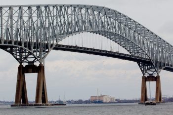
Francis Scott Key Bridge
I drove to White Marsh, north of Baltimore this morning on an extended errand. Cathy was working all morning so I thought I’d add a little photography to my return trip. I stopped at North Point State Park with it’s stone breakwater extending well out into the Chesapeake Bay. I also walked part of the wetland trail but it was pretty quiet, without even many birds. I might return in the spring or summer and walk their Black Marsh Trail, which looks promising. Then I drove across the Francis Scott Key Bridge and found a good vantage for photographs at Fort Armistead Park (which doesn’t have much to recommend it, frankly). The FSK isn’t the biggest or most impressive bridge in the area, but it’s a pretty big thing.
Ferns
We walked a 32⁄3 mile loop today at the Patuxent River State Park, just upstream from Triadelphia Reservoir. We started at the parking area on Georgia Avenue (MD 97) where it crosses the Patuxent River, taking the trail closest to the river (the ‘Yellow’ trail) almost to Howard Chapel Road. The trail then loops to the south and west and we turned onto the ‘Red’ trail, crossing Howard Chapel Road, looping around and then returning to Howard Chapel Road near the Howard Chapel Cemetery. On the way back through the woods I took the only photo taken on the walk, of these ferns.


